


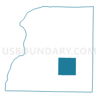
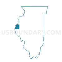
HARMONY Voting District, Hancock County, Illinois
About
Outline

Summary
| Unique Area Identifier | 571107 |
| Name | HARMONY Voting District |
| County | Hancock County |
| State | Illinois |
| Area (square miles) | 37.58 |
| Land Area (square miles) | 37.58 |
| Water Area (square miles) | 0.01 |
| % of Land Area | 99.98 |
| % of Water Area | 0.02 |
| Latitude of the Internal Point | 40.32629840 |
| Longtitude of the Internal Point | -91.09371950 |
Maps

Graphs
Select a template below for downloading or customizing gragh for HARMONY Voting District, Hancock County, Illinois


Neighbors
Neighoring Voting District (by Name) Neighboring Voting District on the Map
- AUGUSTA Voting District, Hancock County, IL
- BEAR CREEK Voting District, Hancock County, IL
- CARTHAGE IV Voting District, Hancock County, IL
- CHILI Voting District, Hancock County, IL
- HANCOCK Voting District, Hancock County, IL
- PRAIRIE Voting District, Hancock County, IL
- ST ALBANS Voting District, Hancock County, IL
- ST MARYS Voting District, Hancock County, IL
Top 10 Neighboring County Subdivision (by Population) Neighboring County Subdivision on the Map
- Carthage township, Hancock County, IL (3,052)
- Augusta township, Hancock County, IL (795)
- Chili township, Hancock County, IL (657)
- St. Mary township, Hancock County, IL (640)
- Prairie township, Hancock County, IL (380)
- St. Albans township, Hancock County, IL (377)
- Bear Creek township, Hancock County, IL (345)
- Harmony township, Hancock County, IL (326)
- Hancock township, Hancock County, IL (255)